 Lýsigagnagátt
Jarðvegur
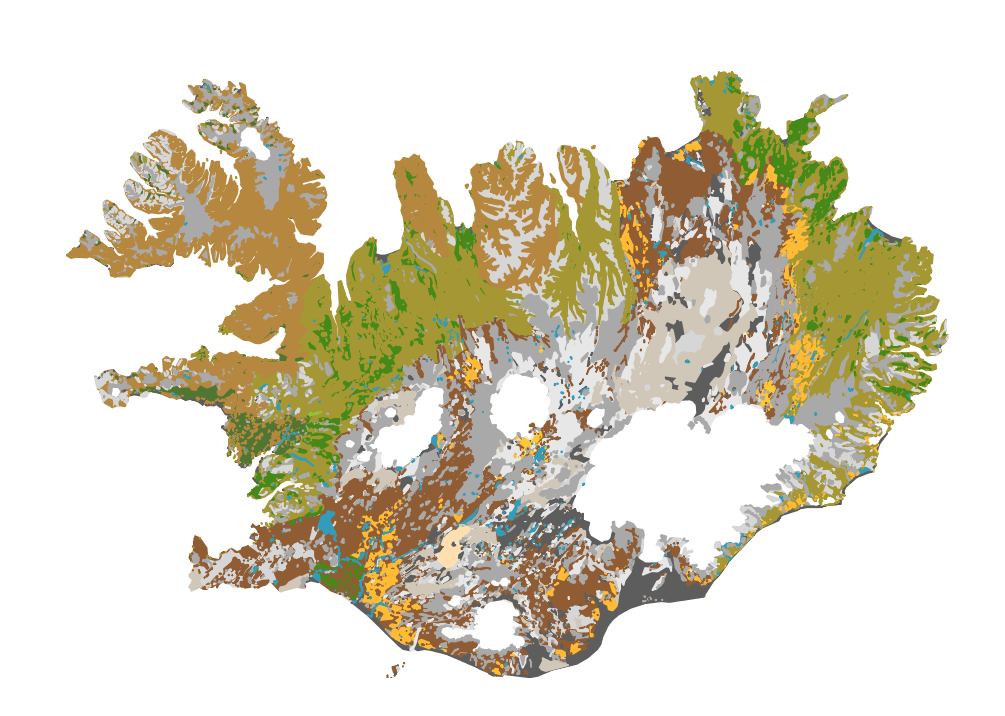
Íslenskur jarðvegur telst til eldfjallajarðar (Andosol) að langmestum hluta, en eldfjallajörð er jarðvegur sem myndast á eldvirkum svæðum heimsins. Eldfjallajörð hefur afar sérstæða eiginleika sem greina hana frá öðrum jarðvegsgerðum. Útbúin var einföld flokkun fyrir íslenskan jarðveg, sem m.a. byggist á alþjóðlegum flokkunarkerfum en einnig á vinnu Björns Jóhannessonar og Þorsteins Guðmundssonar. Flokkunin gerir greinarmun á i) jarðvegi auðna (glerjörð sem skiptist í melajörð, malarjörð, sandjörð og vikurjörð; ii) jarðvegi gróins lands með sortueiginleika (sortujörð, sem skiptist í brúnjörð, votjörð og svartjörð), iii) lífrænni mójörð og að síðustu iv) öðrum jarðvegi sem er margvíslegur að gerð. Í síðasta flokknum er bergjörð útbreiddust, en auk þess má nefna frerajörð sífrerasvæða og kalkjörð. Jarðvegskortið var unnið á grundvelli sniða og jarðvegssýna sem safnað hefur verið víða um landið. Kortið er á vektora formi og í mælikvarða 1:500 000. Það er m.a. hluti evrópska jarðvegskortsins.
A soil map of Iceland:
The Soil map classification separates between; 1) andic soils, which are Brown Andosols, Gleyic Andosols and Histic Andosols; 2) Vitrisols, soils of deserts, which are divided into Cambic Vitrisols, Gravelly Vitrisols, Arenic Vitrisols and Pumice Vitrisols iii) Histosols, and iv) other soil types such as Cryosols and Leptosols. The classification system is in part based on WRB system and Soil Taxonomy and earlier work by Björn Jóhannesson and Þorsteinn Guðmundsson (see English Summary and 1. table in http://www.moldin.net/uploads/3/9/3/3/39332633/jardvegskort_2.pdf). The map is in a coarse scale (1:500 000) and is not intended to use for particular points on the landscape. It is rather an overview. It has been incorporated into the EU soil database and the Circumpolar soil map.
Simple
- Date (Creation)
- 2009-10-01
- Citation identifier
- {1C9025A8-A867-4F39-AA4E-302310C14FDA}
- Point of contact
-
Organisation name Individual name Electronic mail address Role Landbúnaðarháskóli Íslands
Point of contact
- Keywords
-
-
Soil
-
Soil map
-
Jarðvegur
-
Jarðvegskort
-
Jarvegsflokkun
-
GSL
-
INSPIRE
-
- Use constraints
- Other restrictions
- Other constraints
- No conditions apply to access and use
- Access constraints
- Other restrictions
- Spatial representation type
- Vector
- Denominator
- 500000
- Language
- ice
- Topic category
-
- Geoscientific information
))
- Reference system identifier
- EPSG / 3057 / 1
- Distribution format
-
Name Version ESRI Shapefile
1.0
Digital transfer options
- OnLine resource
-
Protocol Linkage Name WWW:LINK-1.0-http--link
http://www.moldin.net/jarethvegskort---soil-map-of-iceland.html moldin.net
WWW:LINK-1.0-http--link
http://www.moldin.net/uploads/3/9/3/3/39332633/jardvegskort_2.pdf Íslenskt jarðvegskort - ritrýnd grein í Náttúrufræðingnum
WWW:LINK-1.0-http--link
https://kort.lmi.is/ Landupplýsingagátt
OGC:WMS
https://gis.is/geoserver/lbhi/wms?service=wms&request=getcapabilities jardvegskort
OGC:WFS-1.0.0-http-get-capabilities
https://gis.is/geoserver/lbhi/wfs?service=wfs&request=getcapabilities&version=1.1.0 lbhi:jardvegskort
- Hierarchy level
- Dataset
Conformance result
- Title
-
Commission Regulation (EU) No 1089/2010 of 23 November 2010 implementing Directive 2007/2/EC of the European Parliament and of the Council as regards interoperability of spatial data sets and services
- Date (Publication)
- 2010-12-08
- Explanation
-
Information required according to INSPIRE Geoportal Validator´s verification report. Validation has not been performed.
- Pass
- Yes
- Statement
-
Jarðvegskortið er útgefið af LbhÍ 2009. Upplýsingar um kortið: Ólafur Arnalds og Hlynur Óskarsson, 2009. Náttúrufræðingurinn 78 (3-4) bls. 107-121.
Kortið má skoða í Vefsjá LbhÍ: http://lbhi.maps.arcgis.com/apps/webappviewer/index.html?id=227b358de2ec4738b9d51c8e86457c0d
Metadata
- File identifier
- {15D66DAC-A389-4330-94C5-31B2EF12F9B6} XML
- Metadata language
- English
- Hierarchy level
- Dataset
- Date stamp
- 2022-05-27T14:32:20
- Metadata standard name
-
INSPIRE Metadata Implementing Rules
- Metadata standard version
-
Technical Guidelines based on EN ISO 19115 and EN ISO 19119 (Version 1.2)
- Metadata author
-
Organisation name Individual name Electronic mail address Role Landbúnaðarháskóli Íslands / Agricultural University of Iceland
Point of contact

)))